|Maps of Western Front|Maps of Eastern Front|Maps of Mediterranean|

Go to 1942 Maps Go to 1943 Maps Go to 1944 Maps Back to 1945 Index Page Go to Korean War Maps

Click on Thumbnail to Enlarge; In Enlargement, Click on Right or Left Side to Advance Maps; Click Middle to Close Enlargement


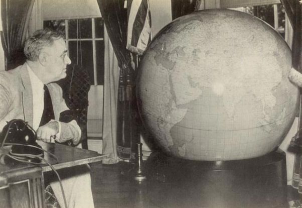
Charlotte News—1945 Map Room
General Marshall's Christmas Gift of Fifty-Inch, 750 lb. Globe to FDR, 1942 FDR's Original Fifty-Inch Globe General Marshall's Christmas Gift of Fifty-Inch, 750 lb. Globe to Winston Churchill, 1942

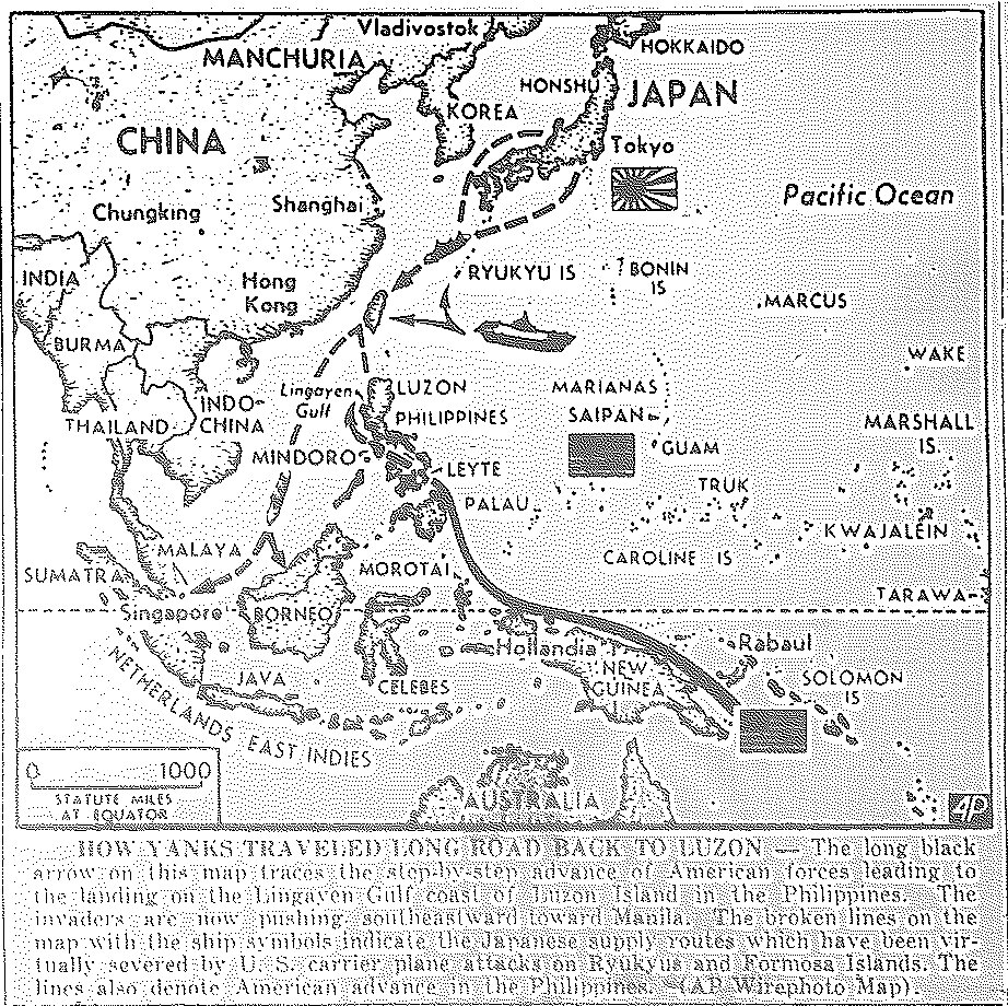
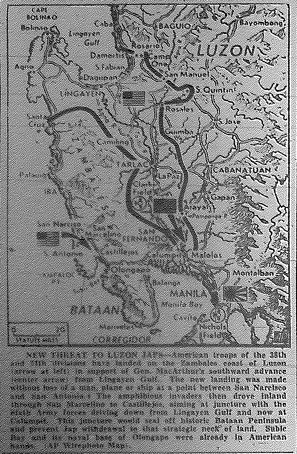
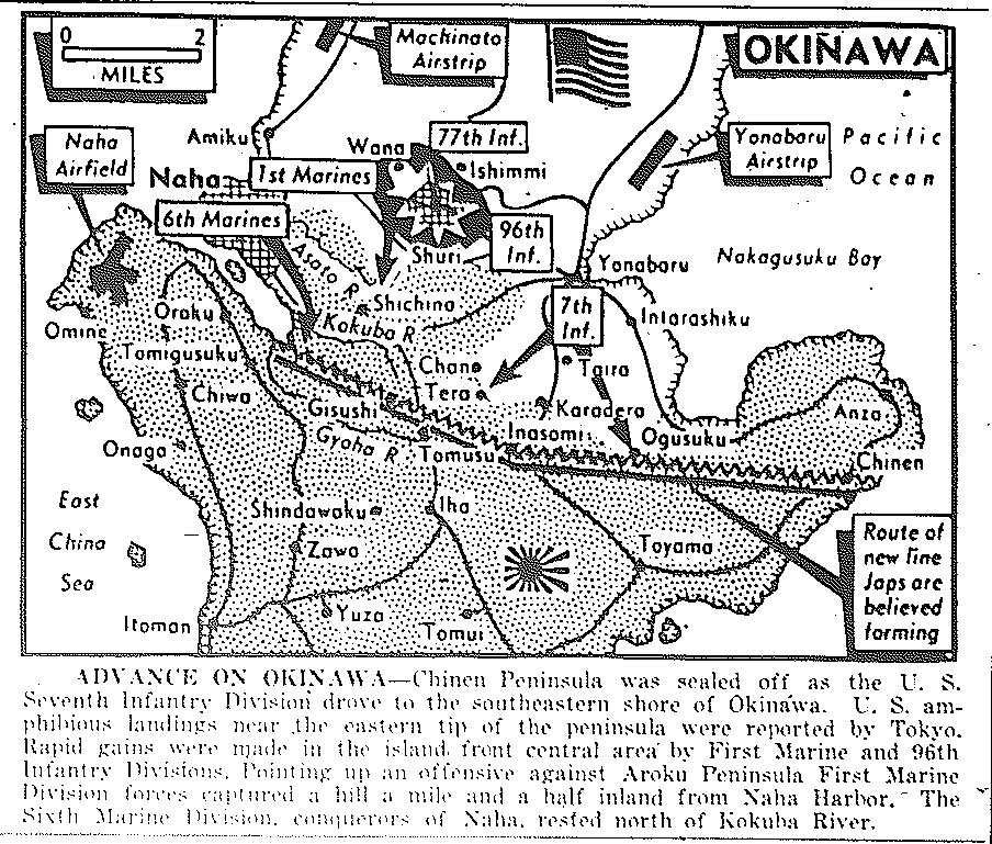
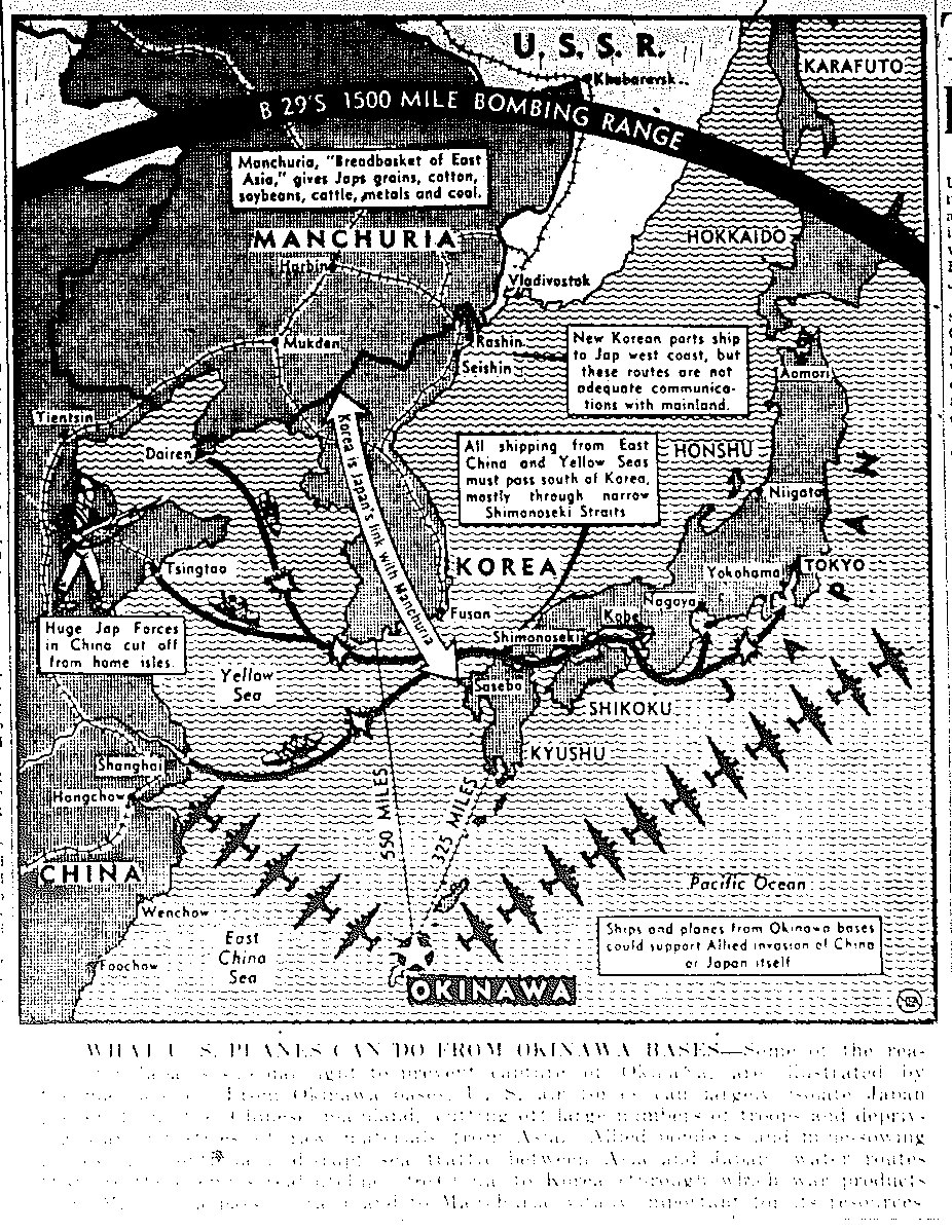
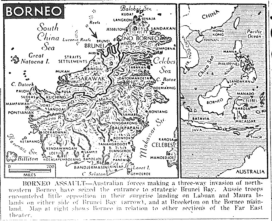
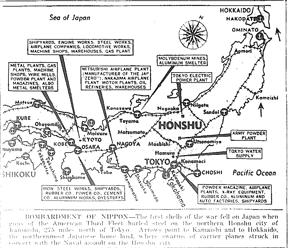
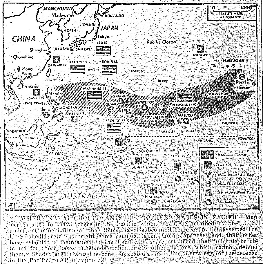
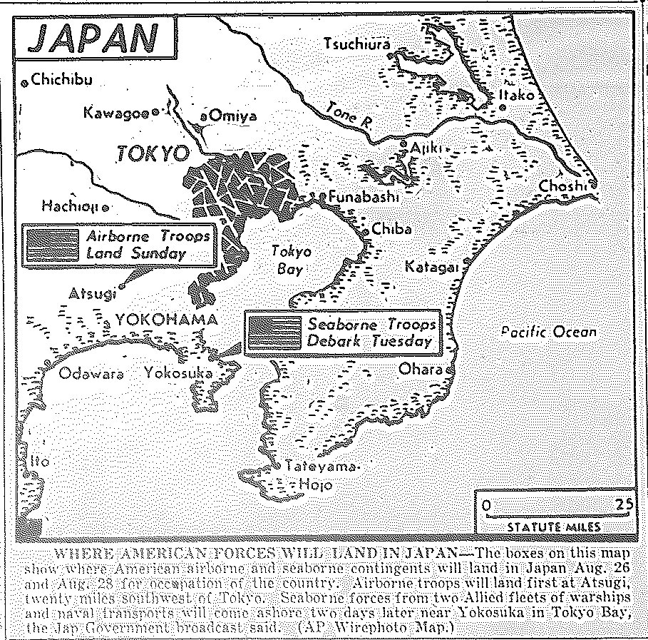
1945 Pacific War Maps

Map of Road to Luzon in Philippines, published January 11, 1945 Map of Third Fleet Planes Pursuing Japanese Convoy from Saigon and Camranh Bay, Indo-China, published January 13, 1945 Map of Luzon Offensive, Capture of Clark Field, Near San Fernando, Beyond San Manuel, Capture of Rosario by Fifth Army Corps, Moving to Baguio, published January 29, 1945 Map of Move on Luzon, published February 1, 1945 Map of Invasion of Iwo Jima, Battle for Corregidor, published February 17, 1945 Map of Invasion of Iwo Jima, Mop-up of Corregidor, published February 19, 1945 Map of Mt. Suribachi on Iwo Jima, published February 23, 1945 Map of Proposed Japanese Railway from Liuchow to Indo-China and Singapore, published February 23, 1945 Map of Invasion of Aka and Tokoshiki in Ryukyus, published March 27, 1945 Map of Pacific, Heaviest raid on Nagoya; Chinese take Sinchang, near Foochow; British clear Rangoon; Allies cleaning up Tarakan; Australians take Wewak, published May 15, 1945 Map of Pacific, 6th Marines enter Naha on Okinawa, bombard Kyushu, published May 17, 1945 Map of Japan, B-29 Priority Targets, published May 22, 1945 Map of Greater Tokyo, 500-plane B-29 Raids on Tokyo, Maranouchi and Shinagawa districts, published May 25, 1945 Map of Japanese withdraw from Central China; Forces in S.E. Asia and East Indies abandoned, isolated, ordered to fight to death, published May 28, 1945 Map of Okinawa, Chinin Peninsula sealed by 7th Infantry, rapid gains by 1st Marine and 96th Infantry, 6th Marines rest after taking Naha, published June 4, 1945 Map of Pacific, Distances from Okinawa airbases to other targets, published June 10, 1945 Map of Borneo, Australians make three-way invasion, seize entrance to Brunei Bay, little opposition, published June 11, 1945 Map of Japan, Navy's first raid, Third Fleet hits Kamaishi, 275 mi. north of Tokyo, carrier planes hit Hokkaido, published July 14, 1945 Map of Navy's Desired Pacific Bases, published August 20, 1945 Map of Japan, Points of Navy and Air Force landings for occupation, published August 22, 1945

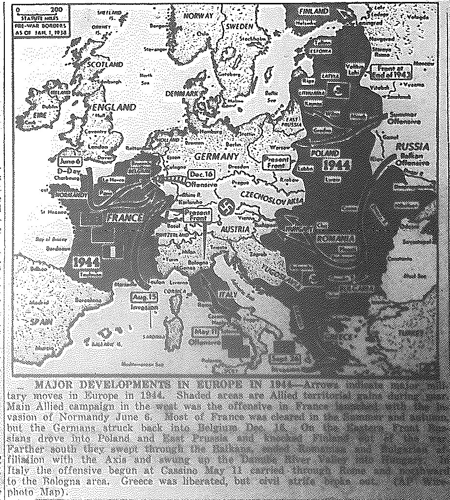
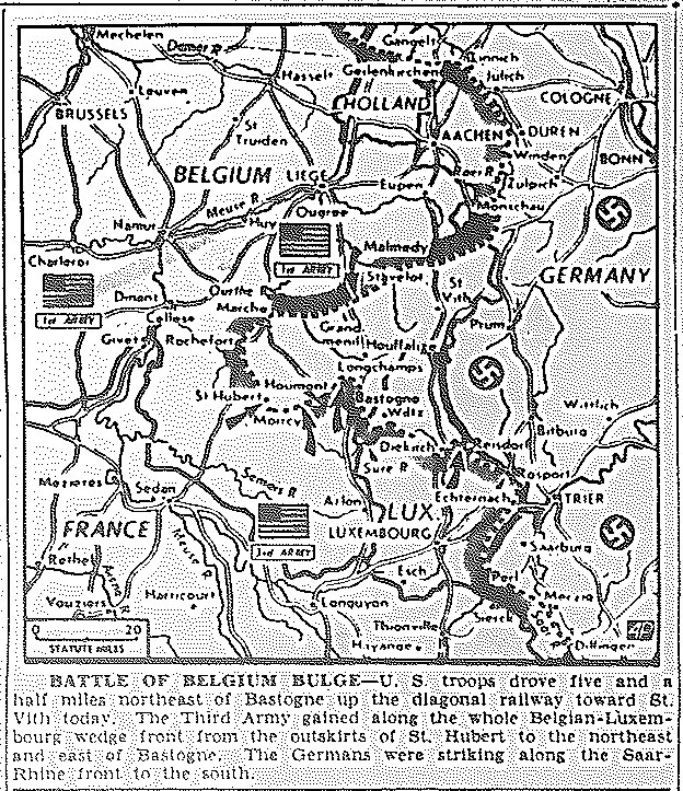
1945 War Maps of Western Front Back to Top

|Maps of Pacific|Eastern Front Maps|Mediterranean War Maps|

Map of 1944 Allied Conquests, published January 1, 1945 Map of Battle of the Bulge in Belgium, Drive Northeast of Bastogne toward St. Vith, published January 3, 1945 Map of Western and Eastern Fronts Squeeze of Germany, published January 24, 1945 Map of Western Front, Canadian 1st Army to Kleve, U.S. First and Third between Aachen and Trier, published February 10, 1945 Map of Western Front, Canadian 1st Army beyond Kleve, U.S. to Pruem; Eastern Front, Russians Take Liegnitz, Encircle Breslau, Take Elbing and Near Danzig, published February 12, 1945 Map of Discussions at Yalta re Polish Territory to be Ceded Russia and to be Taken from Germany, published February 14, 1945 Map of Western Front, Third Army to Trier, Crossing Saar south of Saarburg, Seventh to Saarbrucken, Capture Half of Forbach, Canadian 1st to Calcar, published February 22, 1945 Map of Western Front, U.S. First and Ninth to Cologne and Dusseldorf, published February 26, 1945 Map of Western Front, First Captures Granterath, Roedingen, and Golzpheim; Ninth to Muenchen Gladbach; Third to Bitburg, published February 27, 1945 Map of Western Front, First Army moves toward Cologne; Ninth and Canadian First toward Duesseldorf, published March 1, 1945 Map of Western Front, Ninth Army reaches Rhine, shelling Duesseldorf; First Army shells Cologne, published March 2, 1945 Map of Western Front, Ninth Army joins Canadian First north of captured Krefeld; Germans flee across Rhine, burn bridges between captured Neuss and Duesseldorf, published March 3, 1945 Map of Western Front, First Army enters Cologne; German blow bridges between captured Homberg and Duisburg across Rhine, published March 5, 1945 Map of Western Front, First Army crosses Rhine south of Cologne and enters Bonn, published March 8, 1945 Map of Western Front, Allies aim for Ruhr Valley, published March 8, 1945 Map of Europe, Allies close on Berlin, across the Rhine in West and across the Oder in East, published March 10, 1945 Map of Western Front, First Army crosses Rhine at Remagen, captures Bonn; First and Third Armies close on Coblenz, control 150 miles of Rhine, published March 10, 1945 Map of Western Front, First and Third Armies trap 23,000 Germans west of Remagen, published March 12, 1945 Map of Western Front, First Army severs Ruhr-Franfurt Road, extending Rhine bridgehead to 13 miles, fighting into Koenigswinter, within 3 miles of open lane to Ruhr, published March 16, 1945 Map of Western Front, Third enters Coblenz at Rhine and Moselle R's, pushes 40 miles southeast, crosses Nahe, cuts Saarland escape; Seventh at Saarbruecken; First takes Koenigswinter, published March 17, 1945 Map of Western Front, Third moves to four mi. from Kaiserslautern, 20+ from Seventh, which breaks Siegfried between Saarbruecken and Zweibruecken; First extends bridgehead to 19.5 mi., published March 20, 1945 Detailed Map of Germany, published March 20, 1945 Map of Western Front, Third Army holds 100 miles of west bank of Rhine, from Coblenz to Ludwigshafen, fighting in Mainz, published March 22, 1945 Map of Western Front, Third Army takes Mainz and Landau; Seventh Army takes Pirmasens, published March 23, 1945 Map of Western Front, Ninth Army and British Second enter Wesel across Rhine; Third Army crosses at Mainz, published March 24, 1945 Map of Europe, Americans, Canadians, and British across Rhine at three points; Russians cross Oder at Kuestrin, published March 26, 1945 Map of Western Front, Third Army drives to Lohr, Fulda, and Wuerzburg; British Second enters Dorsten; Seventh and First Armies advance, published March 28, 1945 Map of Western Front, British and Ninth Armies move beyond Muenster; First and British encircle Ruhr; Third moves north from Frankfurt; Seventh menaces Furth and Nuernberg, published March 29, 1945 Map of Europe, British and Ninth drive toward Weser River; First hits Paderborn; Third less than 100 mi. from Czechoslovakia; Seventh, toward Nuernberg; Russians envelop Vienna, published March 30, 1945 Map of Europe, Possible joinder of Third Army with Russian First and Second Ukrainian Armies to cut off Southern Germany, published March 31, 1945 Map of Europe, Ruhr closed off, Kassel mop-up; Third Army spearheads to Leipzig, Nuernburg, Czechoslovakia, published April 2, 1945 Ruhr cut by 1st and 9th, joined at Lippstadt; 3rd in Kassel, Fulda, near Eisenach; 2nd in Muenster and Rheine; 7th to Nuernburg, Stuttgart, Heilbronn; Russians flank Vienna, move to Bratislava, published April 3, 1945 Map of Europe, British and Canadians to Zuider Zee on rocket coast, and Emden; Ruhr being shrunk, published April 5, 1945 Map of Europe, British close on Emden and Bremen; Americans move on Hannover and Eisleben, 90 miles from Berlin, published April 7, 1945 Canadians close on Emden, British on Bremen, across Aller, menacing Hamburg; Americans across Elbe, move on Halle and Leipzig, 50+ miles from Berlin, published April 12, 1945 Map of Europe, Third captures Hof, 7 mi. from Czech border; Seventh 8 mi. from Nuernburg; Ninth 45 mi. from Berlin, published April 16, 1945 Map of Europe, Third captures Plauen, 75 mi. from Russian lines, 6 mi. from Czech border; Seventh in Nuernburg; Russians launch offensive along Oder, published April 17, 1945 Map of Europe, Emden, Bremen, Hamburg besieged; Seventh on Elbe and Mulde; Leipzig captured; Dessau, Chemnitz, Nuernburg under assault, push to join Third and Soviet Armies, published April 20, 1945 Map of Europe, Third captures Asch, drive toward Pilsen and Prague; Russians and Third 25 miles apart; Russians begin siege of Berlin, enter suburbs, published April 21, 1945 Map of Berlin, Russians shelling center, reach Unter Den Linden and Anhalter Station, and in Neukoelln, control quarter of city, published April 23, 1945 Map of Berlin, Russians fighting on Mueller Strasse, Landsberger and Frankfurter Strassen, in Templehof area, published April 24, 1945 Map of Eastern Europe, Russians and 1st Army link near Torgau, 75 mi. from Berlin; 3rd and 7th overrunning Czech., driving to Linz and Munich; Dresden outflanked by Russians and Americans, published April 27, 1945 Map of Europe, Surrender, V-E Day, Ten Dates to Remember in European War, published May 8, 1945 Map of Europe, Germany's new borders, published June 5, 1945

1945 War Maps of Eastern Front Back to Top

|Maps of Pacific|Western Front Maps|Mediterranean War Maps|

Map New Red Army Offensive—Vistula Bridgehead West of Baranow, East Prussia, Czechoslovakia, published January 15, 1945 Map of Taking of Warsaw, Approach to Lodz, Breslau, published January 18, 1945 Map of Taking of Bydgoszez, Approach to Poznan, 137 Miles from Berlin, published January 23, 1945 Map of Entry of Brandenburg Province, 91 Miles from Berlin, published January 26, 1945 Map of Move Toward Berlin and Surrounding of Breslau and Scheidemuhl, published January 29, 1945 Map of Soviet Move Toward Berlin, Capture of Wronki and Pulewy, published January 30, 1945 Map of Eastern Front, Russians to Oder, 39 Miles from Berlin, Koenigsberg Near Fall, published February 1, 1945 Map of Eastern Front, Gains Since Jan. 12 Start of Winter Offensive, published February 3, 1945 Map of Eastern Front, Soviets pierce Oder Line, near Frankfurt, Kuestrin, published February 8, 1945 Map of Eastern Front, Soviets Threaten Stettin, Breslau, published February 9, 1945 Map of Eastern Front, Allied Bombing of Dresden, Cottbus; Soviets Move Toward Dresden, Breslau, published February 16, 1945 Map of Eastern Front, Russian Attacks Along Oder; Kuestrin-Frankfurt Line Overrun by Soviets; Stettin to Guben and Forst Aflame, published March 14, 1945 Map of Eastern and Western Front Gains in March, published March 23, 1945 Map of Berlin, Russians shelling center, reach Unter Den Linden and Anhalter Station, and in Neukoelln, control quarter of city, published April 23, 1945 Map of Berlin, Russians fighting on Mueller Strasse, Landsberger and Frankfurter Strassen, in Templehof area, published April 24, 1945 Map of Eastern Europe, Russians and 1st Army link near Torgau, 75 mi. from Berlin; 3rd and 7th overrunning Czech., driving to Linz and Munich; Dresden outflanked by Russians and Americans, published April 27, 1945 Map of Europe, Surrender, V-E Day, Ten Dates to Remember in European War, published May 8, 1945 Map of Europe, Germany's new borders, published June 5, 1945

1945 War Maps of Mediterranean Back to Top

|Maps of Pacific|Western Front Maps|Eastern Front Maps

Map of Syria, French garrison surrenders at Soucida; British intervene; Druz troops threaten march on Damascus, published June 1, 1945


|Maps of Pacific|Western Front Maps|Eastern Front Maps|

Go to 1942 Maps Go to 1943 Maps Go to 1944 Maps Back to 1945 Index PageGo to Korean War Maps


Framed Edition
[Return to Links-Page by Subject] [Return to Links-Page by Date] [Return to News<i><i>--</i></i>Framed Edition]
Links-Date -- Links-Subj.