|Maps of Central Europe| Maps of Italy|Maps of Russian Front|

Go to 1942 Maps Go to 1943 Maps Go to 1945 Maps Back to 1944 Index PageGo to Korean War Maps

Click on Thumbnail to Enlarge; In Enlargement, Click on Right or Left Side to Advance Maps; Click Middle to Close Enlargement


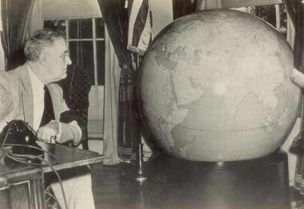
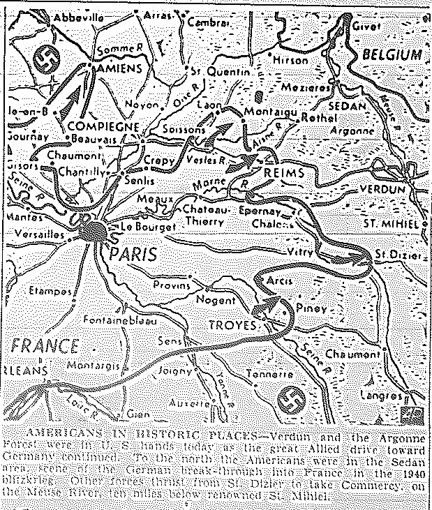
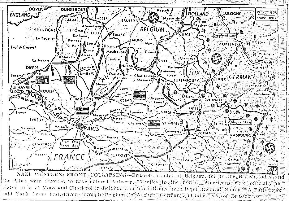
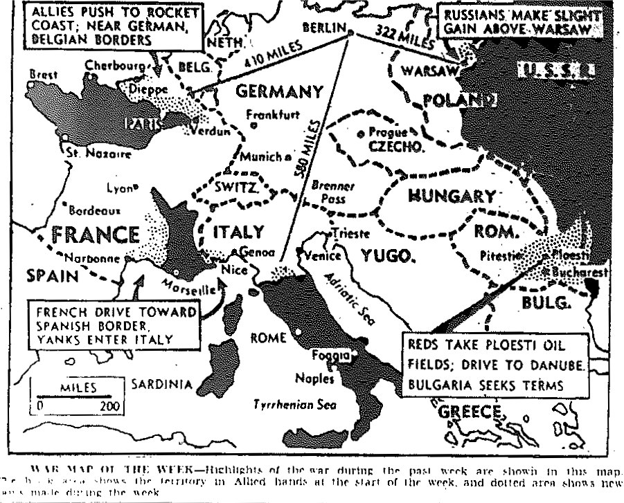
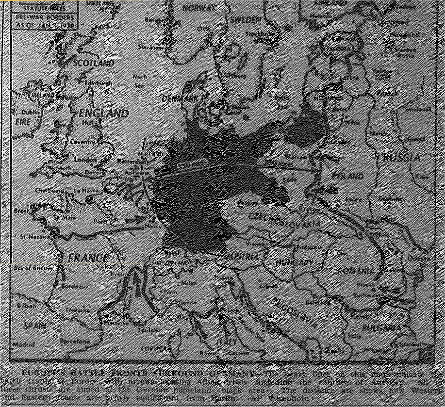
Charlotte News—1944 Map Room
General Marshall's Christmas Gift of Fifty-Inch, 750 lb. Globe to FDR, 1942 FDR's Original Fifty-Inch Globe General Marshall's Christmas Gift of Fifty-Inch, 750 lb. Globe to Winston Churchill, 1942

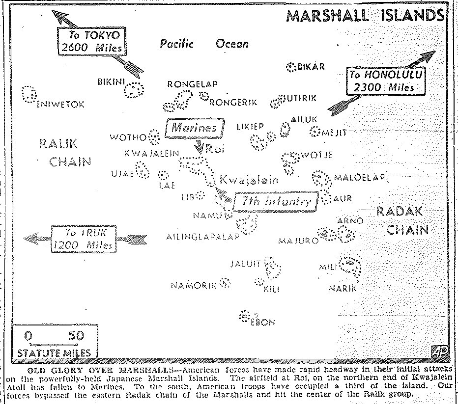
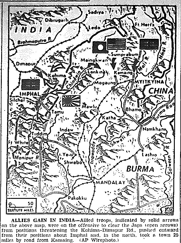
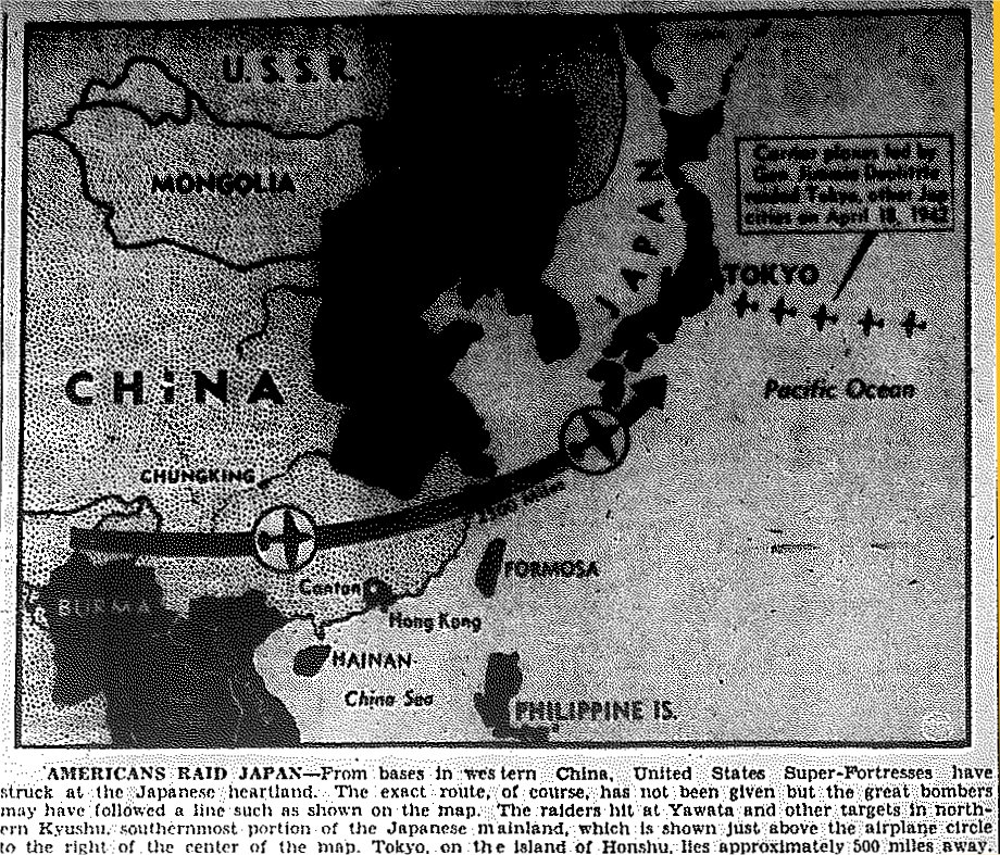
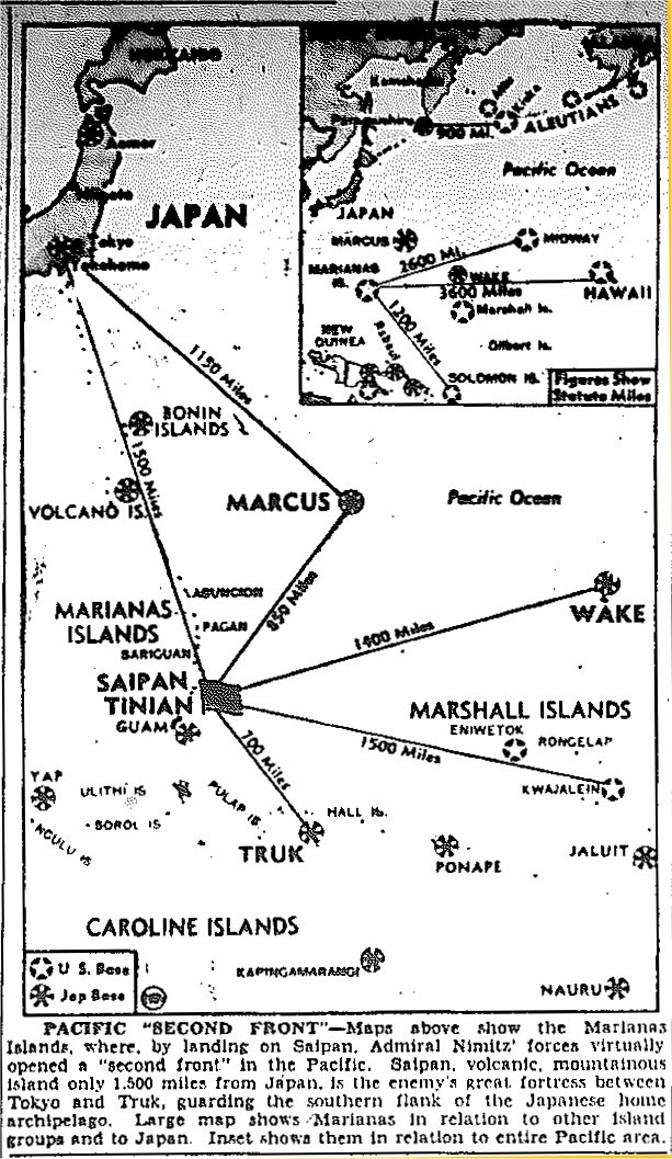
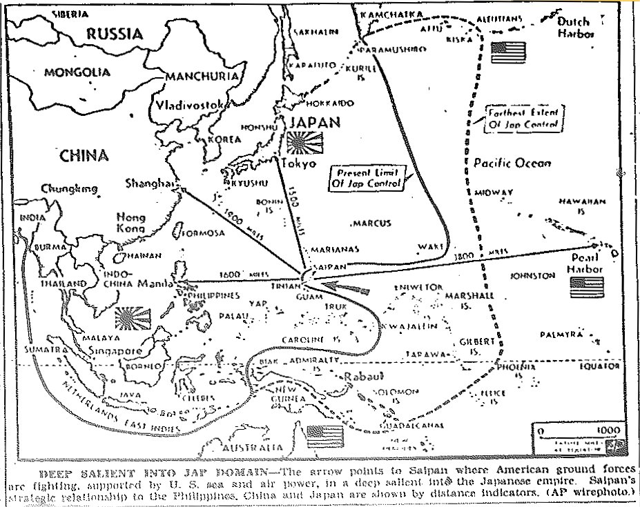
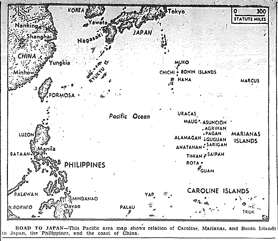
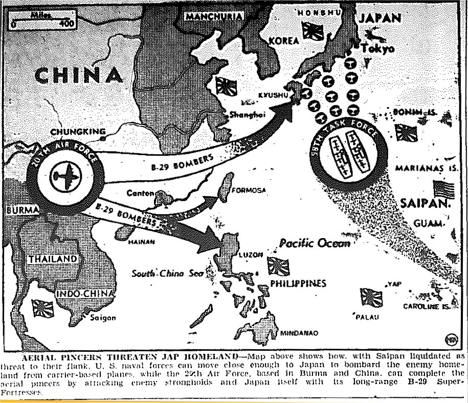
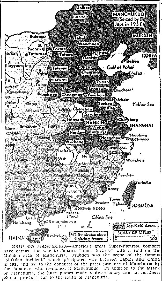
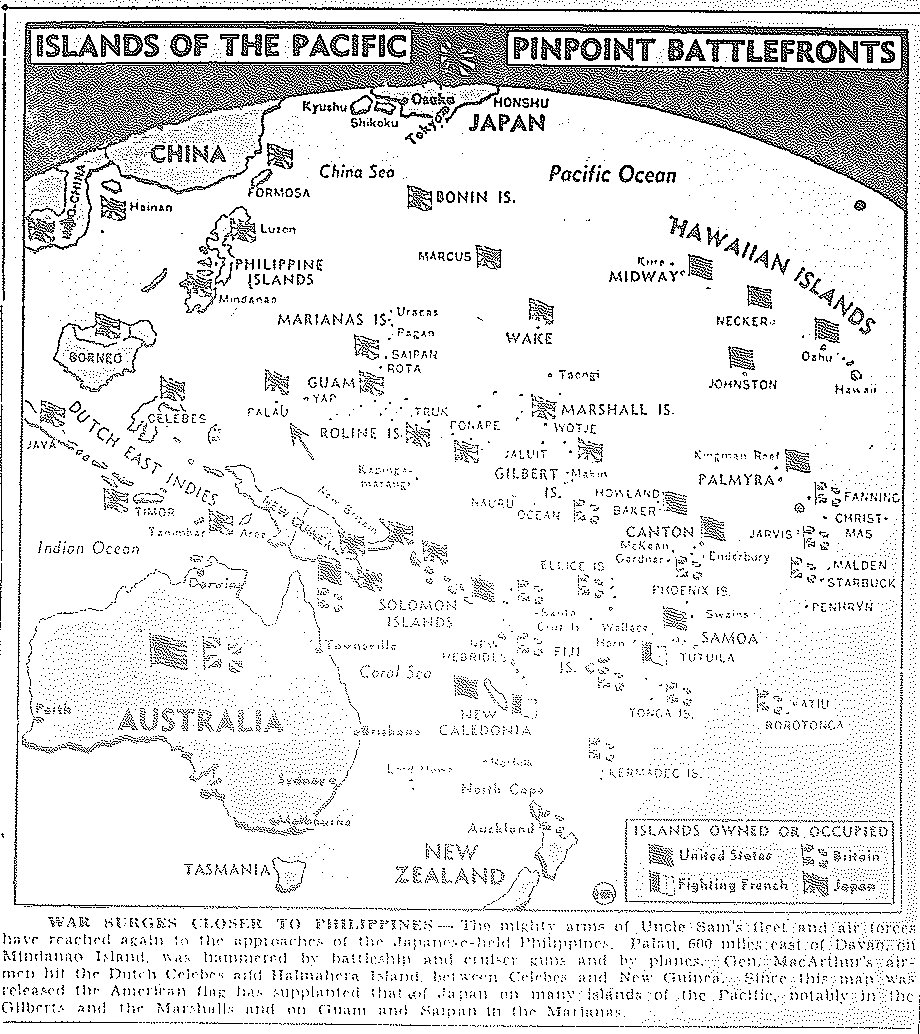
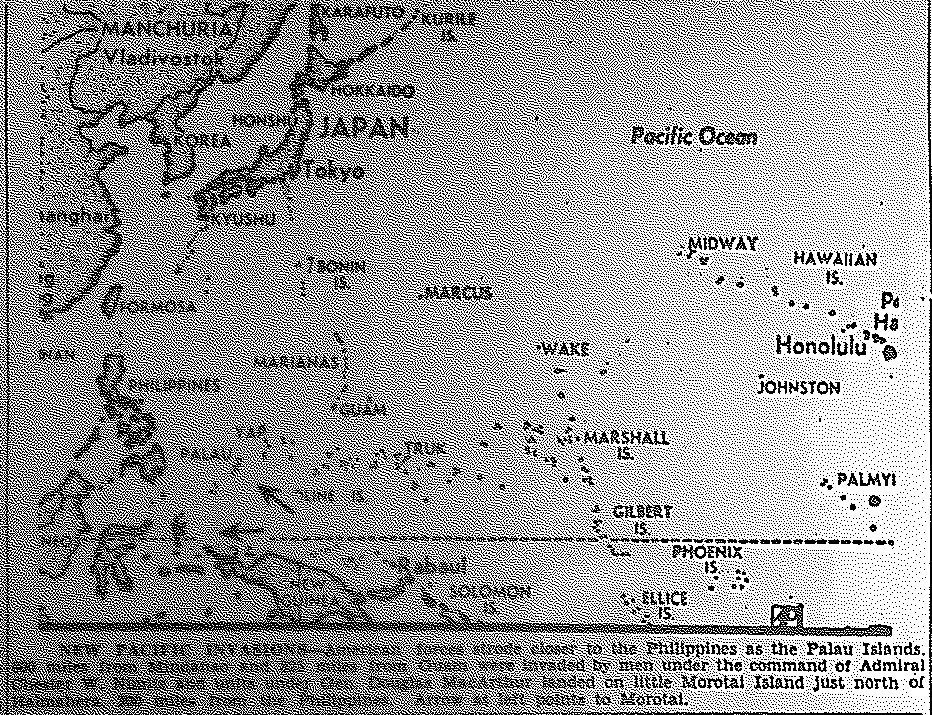
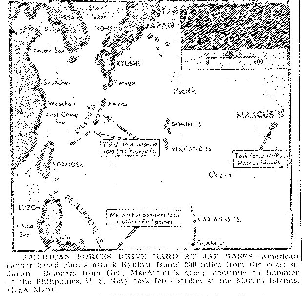
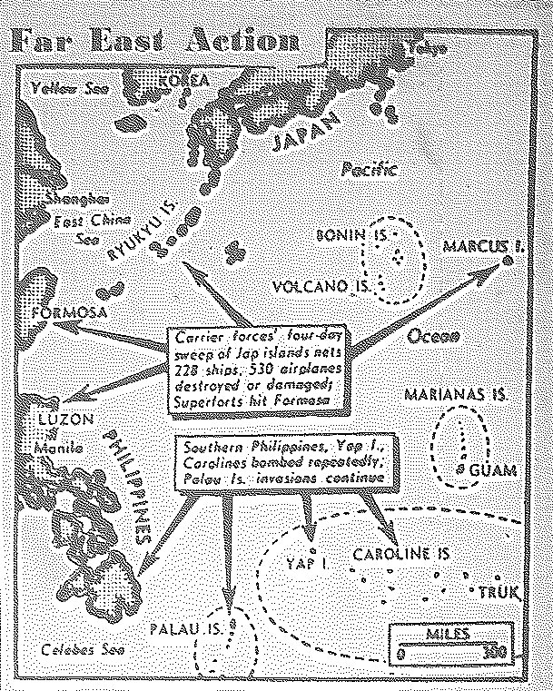
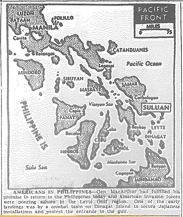
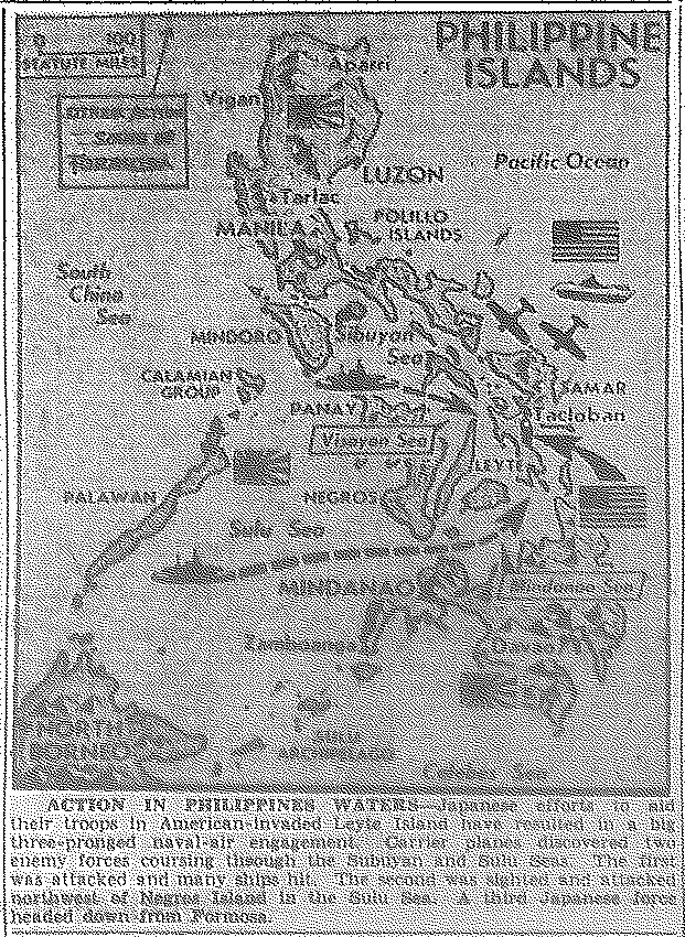
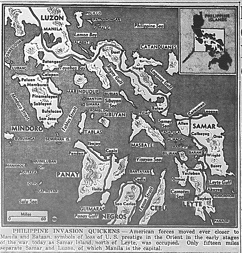
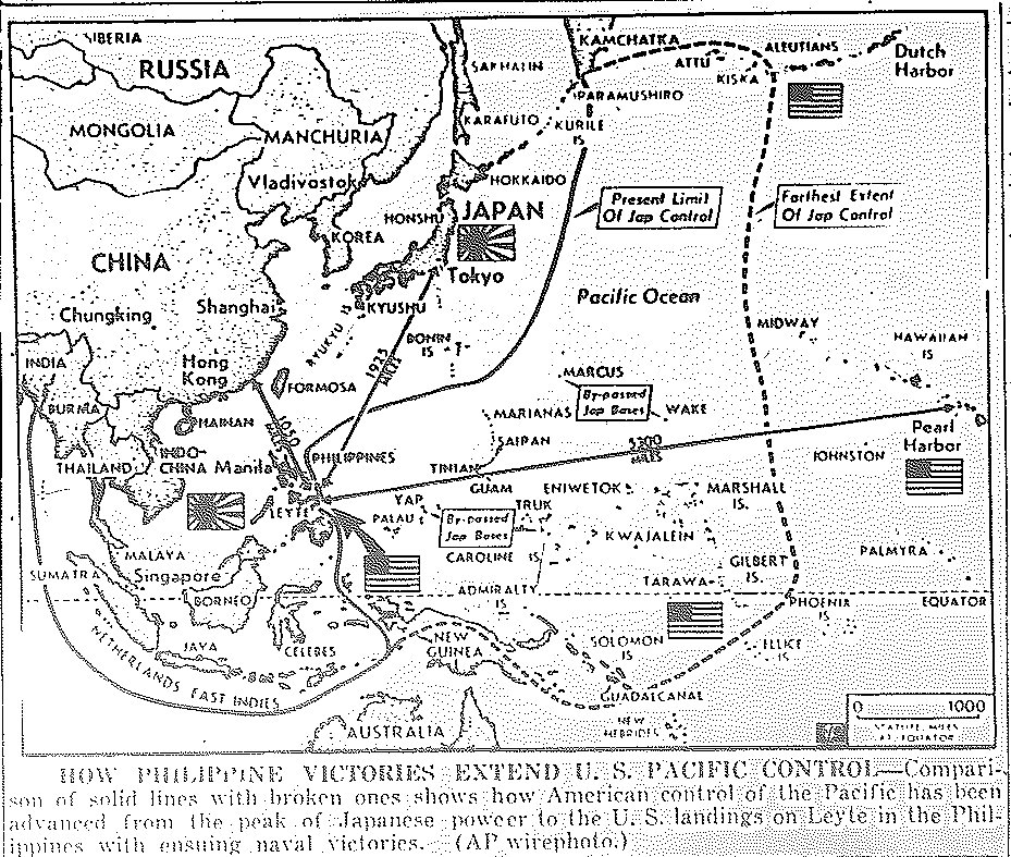
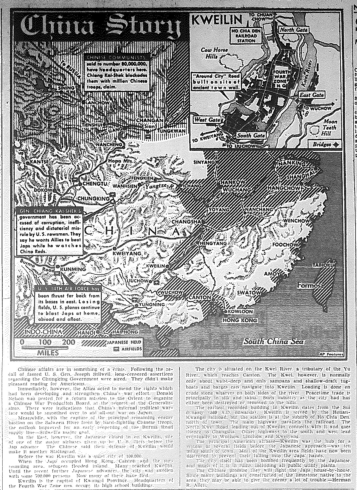
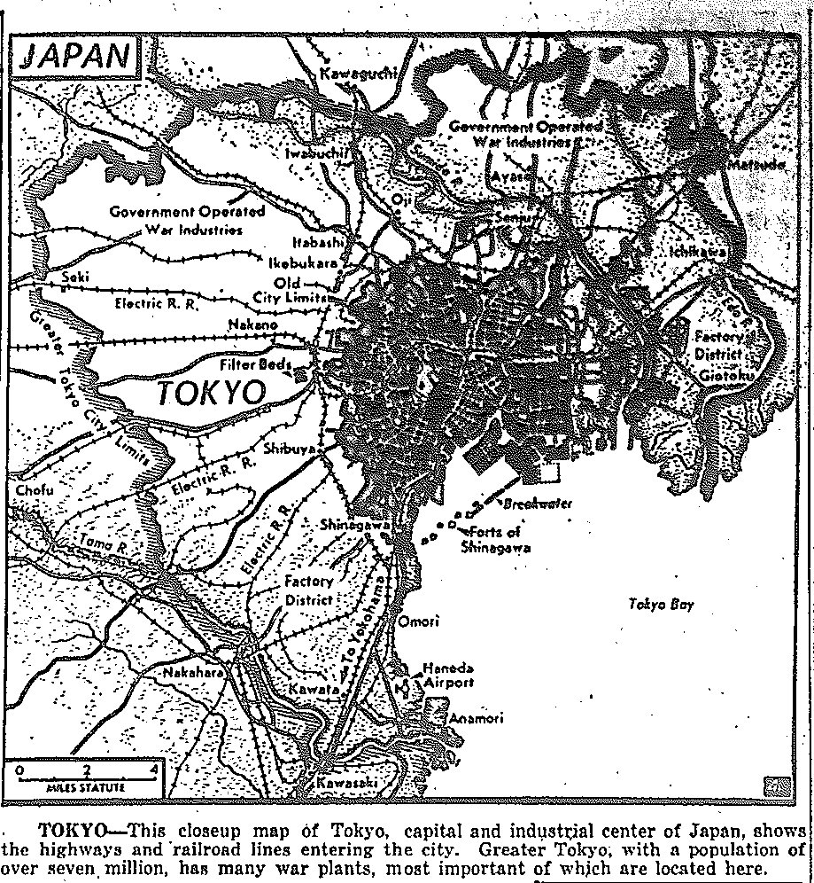
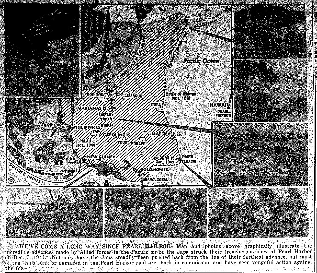
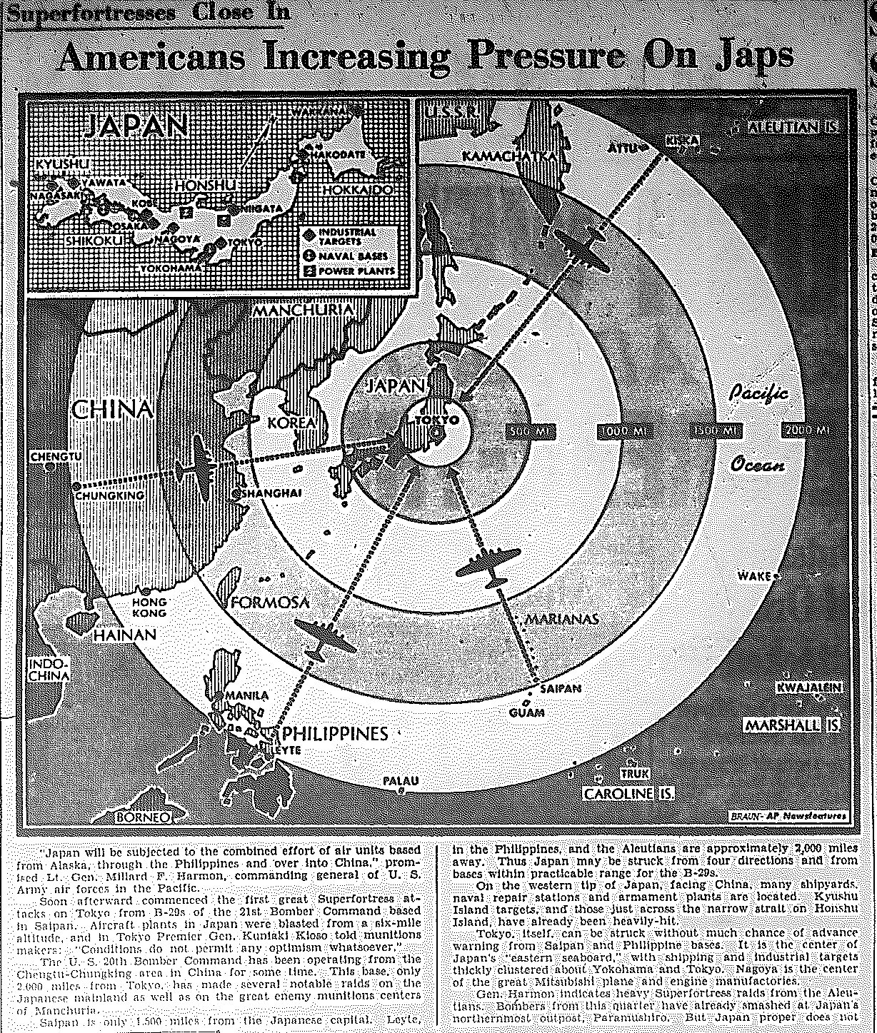
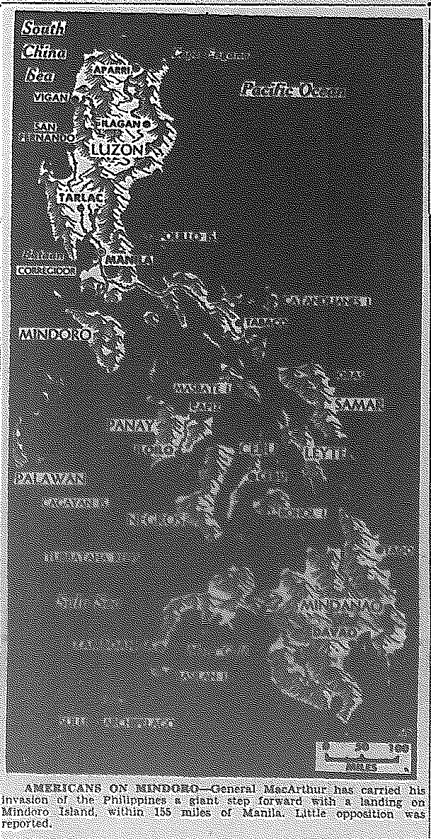
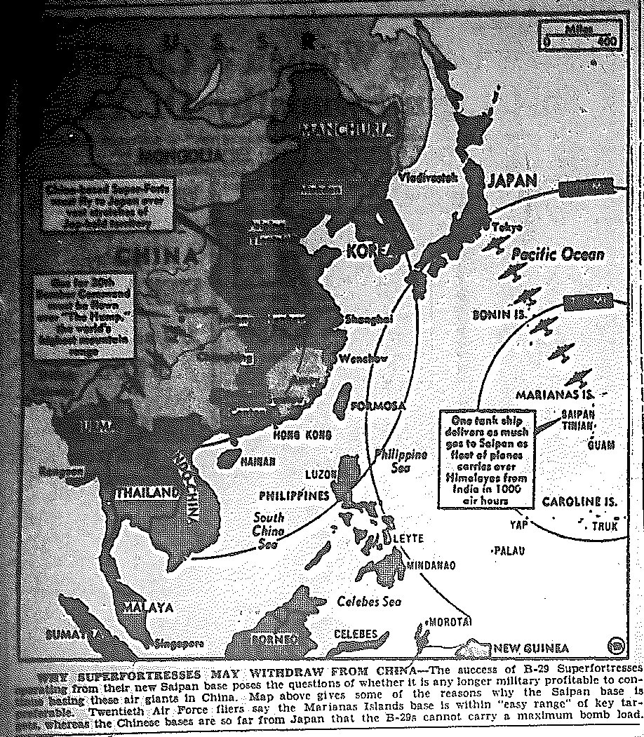
1944 Pacific War Maps

Map of Pacific, Marshall Islands, published February 1, 1944 Map of Marshall Islands, published February 3, 1944 Map of Kurile Islands, Paramushira, published February 7, 1944 Map of Pacific, Truk, published February 18, 1944 Map of Emirau, published March 23, 1944

Map of Pacific, Palau, published March 31, 1944 Map of Pacific, Marshalls, Victory, published April 5, 1944 Map of India, Kohima-Dimapur Rd., published April 21, 1944 Map of Pacific, B-29 Route from Chengdu, China to Yawata, Japan, published June 16, 1944 Map of Pacific, Landing on Saipan in Marianas Islands, Opening of Pacific 'Second Front', published June 20, 1944 Map of Pacific, Landing on Saipan in Marianas Islands, published June 24, 1944 Map of Pacific, Potential Island Paths to Japan, published June 30, 1944 Map of Pacific, Potential B-29 and Carrier-Based Bombing Paths to Japan and Philippines from China and Hollandia, published June 30, 1944 Map of Pacific, B-29 Raid on Mukden in Manchuria, published July 29, 1944 Map of Pacific, Navy and Air Raid on Celibes and Palau, published September 13, 1944 Map of Pacific, Pacific, Landing on Palau and Moritai Island, published September 15, 1944 Map of Pacific, Air Attack on Ryukyu Islands, Navy Attack on Marcus Islands, published October 12, 1944 Map of Pacific, Air Attack on Formosa, Ryukyu Islands, and Luzon in the Philippines, published October 13, 1944 Map of Pacific, Air Attack on Formosa, Ryukyu Islands, Luzon in the Philippines, published October 16, 1944 Map of Pacific, Landings at Leyte Gulf in the Philippines, published October 19, 1944 Map of Pacific, Landings at Leyte Gulf and Dinagat Island in the Philippines, published October 20, 1944 Map of Pacific, Naval Battle in Subuyan and Sulu Seas in the Philippines, published October 25, 1944 Map of Pacific, Landing on Samar Island in the Philippines, published October 28, 1944 Map of Pacific, Overall View of Allied Advances, published October 30, 1944 Map of Kweilin, Western China, published November 15, 1944 Map of Tokyo, published December 7, 1944 Map of Allied Advances Since Aftermath of Pearl Harbor, published December 7, 1944 Map of Allied Bombing Bases Surrounding Japan: Aleutians, Philippines, Saipan, and Chengtu, China, published December 9, 1944 Map of Allied Bombing of Mukden and Southern Manchuria in China, published December 13, 1944 Map of Industrial Center of Japan at Nagoya, published December 16, 1944 Map of Allied Landing on Mindoro Island in Philippines, published December 16, 1944 Map of China B-29 Route vs. More Efficient Saipan Route, in Terms of Gas Supply and Distance to Targets, published December 18, 1944

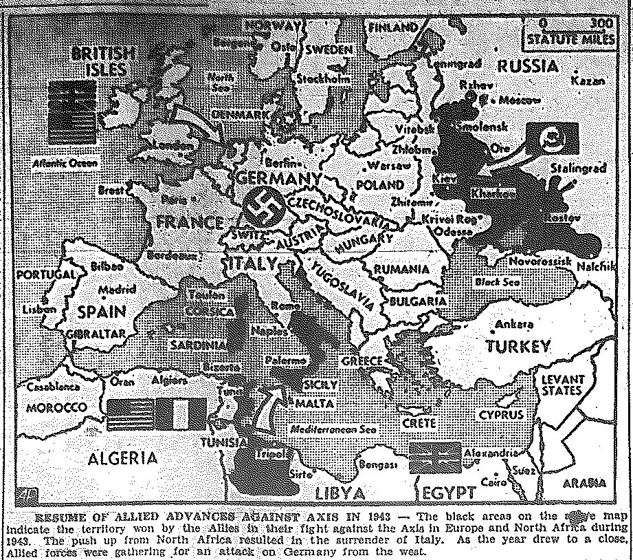
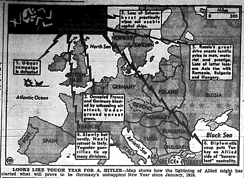
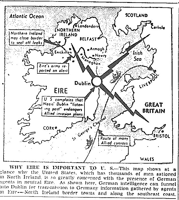
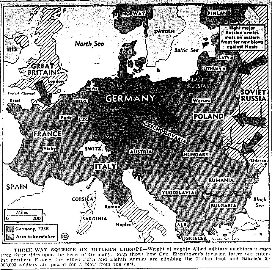
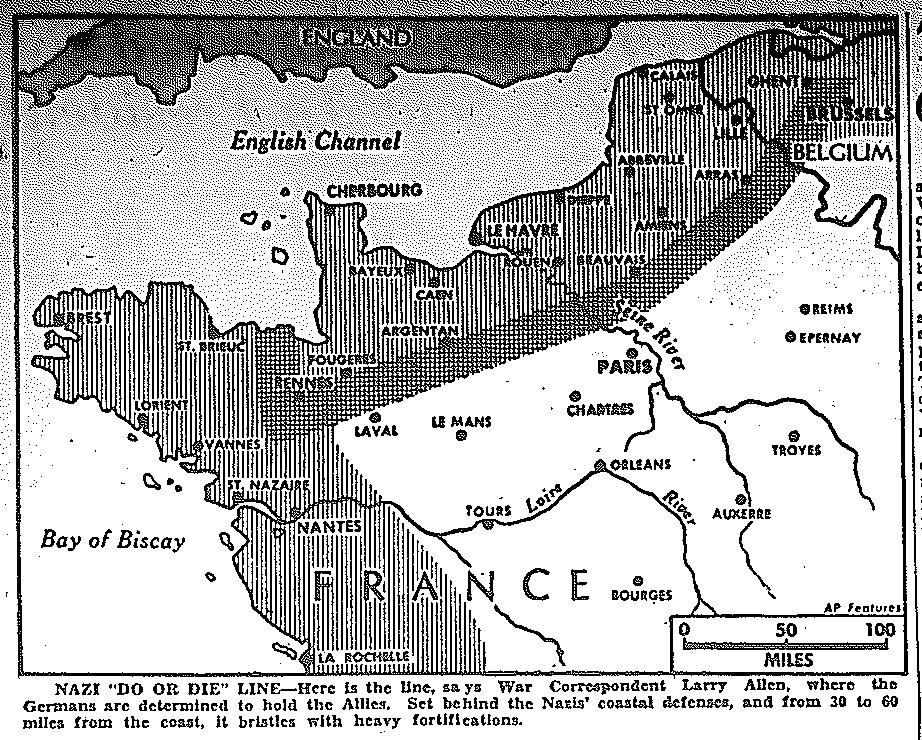
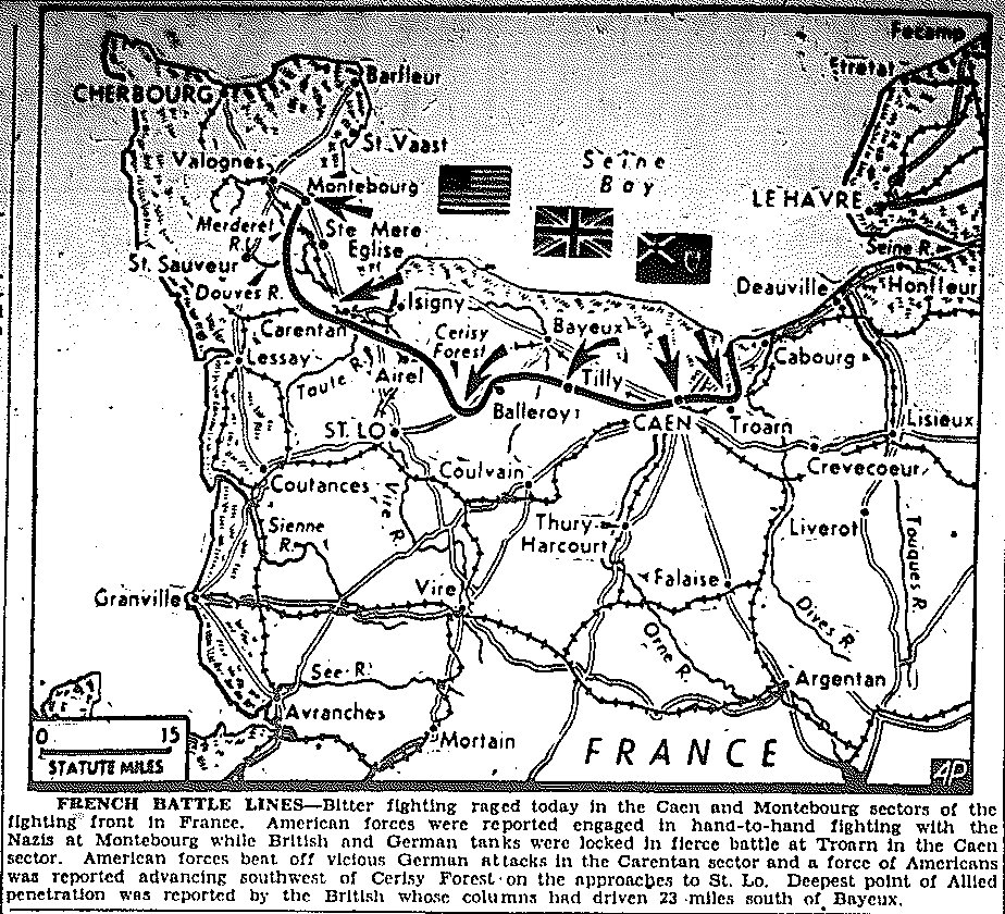
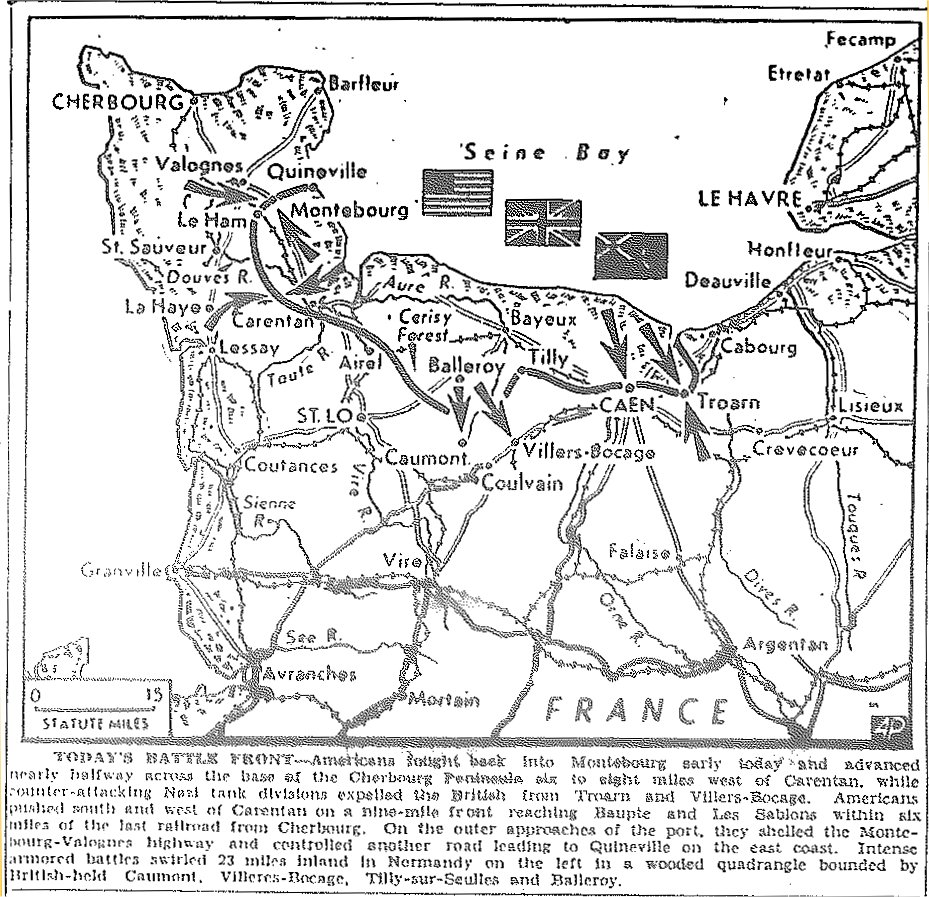
1944 War Maps of Central and Southern Europe Back to Top

|Maps of Pacific|Russian Front Maps|Maps of Italy|

Map of 1943 Allied Conquests, published January 1, 1944 Map of Prospective European Conquests, published January 5, 1944 Map of Ireland, published March 13, 1944 Map of Occupied Europe, published March 18, 1944 Map of Path of Potential Russian Entry to Eastern Europe, published April 19, 1944 Map of Danube Bombing, published April 21, 1944 Map of Invasion Coast of France, published May 2, 1944 Map of Dual Pincers from East, West, and South on Germany, published May 5, 1944 Map of Deployment of German Troops and Commanders, published May 6, 1944 Map of D-Day Invasion of Normandy Coast, published June 6, 1944 Map Two of D-Day Invasion of Normandy Coast, published June 6, 1944 Map Three of D-Day Invasion of Normandy Coast, published June 6, 1944 Map Three of D-Day Invasion of Normandy Coast, alternate caption, published June 6, 1944 Map Three-Pronged Approach to Invasion of Germany, from France, Italy, and Russia, published June 7, 1944 Map of D-Day Invasion of Normandy Coast, published June 8, 1944 Map of Normandy Coast, published June 9, 1944 Map of Drive for Cherbourg, published June 10, 1944 Map Three-Pronged Approach to Invasion of Germany, from France, Italy, and Russia, published June 12, 1944 Map of Drive for Cherbourg, Taking of Montebourg, published June 13, 1944 Map of Nazi Hold Line in France, published June 13, 1944 Map of Drive for Cherbourg, Battles for Caen and Montebourg, published June 14, 1944 Map of Drive for Cherbourg, published June 15, 1944 Map of Cherbourg, published June 22, 1944 Map of Three-Pronged Approach to Invasion of Germany, from France, Italy, and Russia, published June 26, 1944 Map of France, General Omar Bradley's First Army Advance, south from St. Lo and west of Caumont, published July 4, 1944 Map of France, General Omar Bradley's First Army Advance, to St. Lo and Lessay, published July 12, 1944 Map of France, Mileage Chart to Paris, published July 26, 1944 Map of France, General Omar Bradley's First Army Advance, Fall of Periers and Lessay, published July 28, 1944 Map of Allied Threats to German Lines, published August 1, 1944 Map of Position of Neutral Turkey, published August 3, 1944 Map of Move Toward Nantes, St. Nazaire, and Brest on Breton Peninsula, and to Le Havre and Paris, published August 4, 1944 Map of Move Toward Nantes, St. Nazaire, and Brest on Breton Peninsula, Taking of Villers Bocage and Rennes, published August 5, 1944 Map of Thrust into Brest and to Loire River, published August 7, 1944 Map of Landing on Marseilles, published August 15, 1944 Map of Nazi Prisoner-of-War Camps, published August 16, 1944 Map of Four-Pronged Approach to Invasion of Germany, from Western and Southern France, Italy, and Russia, published August 17, 1944 Map of Third Army Drive toward Paris, Taking of Dreux, Chartres, Chateaudun, and Orleans, Pressure at Caen and Argentan, published August 18, 1944 Map of Progress: 3rd Army Reaches Seine, South Forces to Toulon, Maquis Uprisings in Brittany, Cent. and South France, Russians to E. Prussia and Warsaw, 5th Army Invades Florence, published August 21, 1944 Map of Allied Drives Toward Paris, published August 22, 1944 Map of Allied Drives in France, published August 22, 1944 Map of Allied Drives in France, published August 23, 1944 Map of France, Drive to Grenoble by American Forces, Investiture of Marseilles, published August 23, 1944 Map of France, Success on All Fronts, published August 24, 1944 Map of France, Taking of Paris, French Forces Successfully Liberate 50,000 Square Miles with Aid of Underground, published August 25, 1944 Map of Four Approaches and Mileage to Berlin, published August 25, 1944 Map of Allied Move into the Marne Area, published August 28, 1944 Map of Allied Drive Toward Belgium, Taking by Third Army of Chateau-Thierry and Soissons, Evacuation of Rouen, Moves Beyond Reims and Laon, published August 30, 1944 Map of British Drive to Amiens, Americans Move Toward Belgium, 3rd Army Captures St. Dizier, 7th Army Moves through Nice, Nazis Fall Back to Lyon in Allied Rhone Valley Offensive, published August 31, 1944 Map of Taking of Verdun and Argonne Forest, Americans in Sedan and Commercy, published September 1, 1944 Map of Taking of Verdun, St. Mihiel, and Commercy by Third Army, published September 2, 1944 Map of Taking of Brussels by British as Allies Enter Antwerp, Americans at Mons and Charleroi, and Reported at Aachen, Germany, published September 4, 1944 Map of Allied Controlled Territory, published September 4, 1944 Map of  War Fronts Encompassing Germany, published September 5, 1944 Map of  Central European Front, Third Army Patrols Enter Germany, published September 6, 1944 Map of German Stand at Siegfried Line, Third Army Moves to Metz and Nancy, First Army on Offensive in Ardennes, published September 7, 1944 Map of Third Army Reaching East Bank of Moselle River, First Army Strikes Along Meuse River from Namur to Anchamps in Belgium, published September 8, 1944 Map of Siegfried Line, published September 8, 1944 Map of Shrinking Nazi Empire, published September 9, 1944 Map of Three-Pronged Approach to Invasion of Germany, from France, Italy, and Russia, published September 9, 1944 Maps of First Penetration of Siegfried Line at Trier; Third Army Joins with Seventh Army, Moving Toward Belfort, published September 13, 1944 Maps of First Penetration of Siegfried Line at Trier; Third Army Joins with Seventh Army, Moving Toward Belfort, published September 13, 1944 Map of Allied Smash against Siegfried Line, published September 14, 1944 Map of Allied Thrust into Balkans to Trap 50,000 Germans, published September 15, 1944 Map of First Army Penetration at Aachen of Siegfried Line, Moving toward Cologne, and in Trier Sector, Third Army Moves toward Strasbourg, published September 16, 1944 Map of Seventh Army Entering Belfort, Third Army Moving Past Metz and Nancy, First Army Moving Toward Cologne, published September 18, 1944 Map of Battle of the Rhine, published September 19, 1944 Map of Move to Flank Siegfried Line through Holland, Moves Toward Cologne and Essen,  published September 20, 1944 Map of Relief to Airborne Troops, published September 25, 1944 Map of Seventh Army Strike into Vosges Mountain Passes to the Rhine, First Army Menaces Siegfried Line near Prum, First Army Captures Remich,  published September 30, 1944 Map of American First Army Drive to the Rhine at Aachen; British Widening Corridor in Holland, against 'S Hertogenbosch, published October 2, 1944 Map of British Invasion of Greece at Patrai, published October 5, 1944 Map of Three-Pronged Approach to Germany: Americans at Aachen; Russian Advances to Belgrade and Budapest; and Russian Advances in Lithuania, published October 9, 1944 Map of First Army Encirclement of Aachen, published October 10, 1944 Map of First Army Attack on Aachen; Third Army Withdrawal from Driant; Seventh Army and French First Army Gains North of Belfort, published October 18, 1944 Map of British and Canadian Drives in Holland, at Antwerp, 'S Hertogenbosch, and Roosendaal, published October 24, 1944 Map of Clean-up of Holland by British and Canadians, Fall of Antwerp Imminent, published October 31, 1944 Map of Landing on Walcherin Island, Drive of British and Canadians to Take Antwerp, Fleeing of Germans Across Maas River, published November 1, 1944 Map of Third Army Drive to Encircle Metz, published November 14, 1944 Map of First and Ninth Armies Drive East of Aachen into Rhineland, British Second Army Approach to Roermund, Holland, published November 17, 1944 Map of 450-mile Western Front, from Holland to Switzerland, published November 22, 1944 Map of Crossing of Rhine East of Strasbourg, Driving of Germans from Strasbourg, published November 24, 1944 Map of Western Front: British 2nd Clear Grubbenvorst; U.S. 9th at Kirchberg; U.S. 1st at Inden; U.S. 3rd to Saarbrucken and Saarlautern; U.S. 7th North of Saarebourg, French Cross Rhine, published November 28, 1944 Map of Western Front, published November 30, 1944 Map of Air View of Western Front, published December 1, 1944 Map of Gains During November on Western Front, published December 2, 1944 Map of Estimated German Divisions Deployed in Europe, published December 4, 1944 Map of Third Army Drive into Saar, published December 6, 1944 Map of Third Army Drive into Saar, published December 9, 1944 Map of Drives on Ruhr and Saar in West, Russian Drive through Hungary to Austria, published December 11, 1944 Map of Battle of the Bulge: German Counter-Offensive Along 80-mile Front from Monschou to the Trier Area, published December 18, 1944 Map of Battle of the Bulge: Allied Capture of Monschau, as Americans Resist German Counter-Offensive, published December 20, 1944 Map of Battle of the Bulge: 3rd Army Rescue of Troops at Bastogne, Driving North to 1st Army; Repulse of German Bulge from Celles 10 Miles to Rochefort, published December 29, 1944

1944 War Maps of Italian Front Back to Top

|Maps of Pacific|Maps of Central and Southern Europe|Maps of Russian Front|

Map of Italy, Cassino, Anzio, published January 24, 1944 Map of Italy, Mt. Cassino, Anzio, published February 15, 1944 Map of Italy, Drive on 'Adolph Hitler Line', south of Cassino, published May 18, 1944 Map of Italy, Drive north of Cassino and on Rome, published May 30, 1944 Map of Sweep into Po River Valley, published September 30, 1944

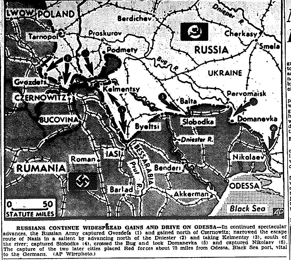
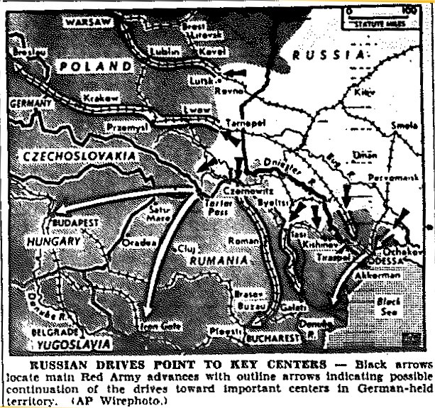
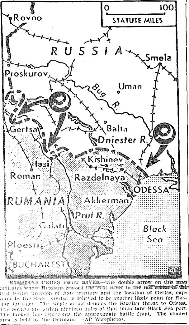
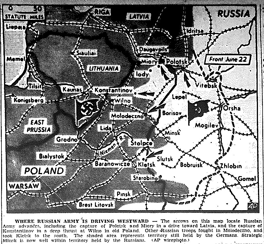
1944 War Maps of Russian Front Back to Top

|Maps of Pacific|Maps of Central and Southern Europe|Maps of Italy|

Map of Russia—White Russia to Ukraine, published January 3, 1944 Map of Russia—Vitebsk, published February 26, 1944 Map of Russia, Finalnd Border, published March 2, 1944 Map of Russia—Dniester River, published March 17, 1944 Map of Russia—Dniester River, published March 21, 1944 Map of Russia—Prut River, published March 28, 1944 Map of Russia—Ukraine, published March 30, 1944 Map of Russian drives on Hungary, published April 3, 1944 Map of Russian drives across Prut River, published April 4, 1944 Map of Russia, drive on Crimea, published April 12, 1944 Map of Russia, Poland, Russian Drives toward Latvia, Wilno, and Warsaw, published July 6, 1944 Map of Poland, Lithuania, and East Prussia, Russian Drives toward Grodno and Lithuania, published July 12, 1944 Map of Poland, Russian Drives toward Warsaw and Lwow, published July 25, 1944 Map of Poland, Russian Drive toward Warsaw, Taking of Stanislawow, Lwow, and Brest-Litovsk, published July 28, 1944 Map of Poland, Russian Drive toward Warsaw, published July 29, 1944 Map of Russian Drive into East Prussia, published August 3, 1944 Map of Poland, Russian Drive toward Warsaw and Czechoslovakia, published August 9, 1944 Map of Poland, Russian Drive toward Warsaw, East Prussia, and Czechoslovakia, published August 12, 1944 Map of Rumania, Surrender and Fighting of Rumanians with Allies, published August 25, 1944 Map of History of Rumania, Paths of Russian Army into Rumania, published August 26, 1944 Map of Rumania and Balkan Revolt against Germany, published August 29, 1944 Map of Russian Advance on Hungary, Internal Revolt against Germany, published October 17, 1944 Map of Russian Advance on Norway, (with incorrect caption), published October 26, 1944 Map of Russian Advance on Budapest, published November 4, 1944 Map of Russian Advance on East Prussia, published November 10, 1944


|Maps of Pacific|Maps of Central and Southern Europe|Russian Front Maps|Maps of Italy|

Go to 1942 Maps Go to 1943 Maps Go to 1945 Maps Back to 1944 Index PageGo to Korean War Maps


Framed Edition
[Return to Links-Page by Subject] [Return to Links-Page by Date] [Return to News<i><i>—</i></i>Framed Edition]
Links-Date Links-Subj.